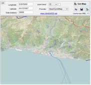
 TERRAIN
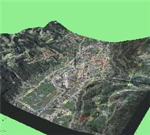
View flat maps Microsoft Bing, 3D scenes with DEM ASTER without using the browser.
If desired, the maps are overlapped in 3D on the ASTER GDEM V2 territory, with 30m horizontal resolution, for a more useful static consultation compared to flat 2D.
Rotations, translations, zooms allow you to "manipulate" the 3D scene using OpenGL 1.1 graphics optimized to obtain the best compatibility with each graphics card.
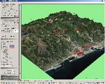
With the help of Bing, overlay road itineraries with route directions that can be copied to external applications, TERRAIN calculates the Line-Of-Sight visibility with respect to any geographical position, exports the results...
TERRAIN is free, the withdrawal is from the Microsoft Store, registration is required to activate it.
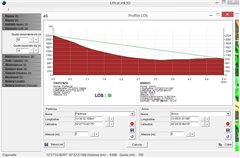
ULTRALINK3D
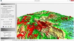
The professional three-dimensional analysis tool, LOS profiles on an internal database that stores all the point-to-point positions analysed, 360° LOS in 3D overlapped with observer-observed quota parameterisation, LOS export in KMZ format, 4/3 terrestrial radius correction for radio horizon simulation, use of local DEM database with a choice of 30m or 90m horizontal resolution.
Free trial version for 30 days, registration is required to download...
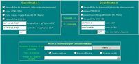
Practical and immediate converter between coordinate systems, transformation from one reference to another directly from your browser without installing any program. It is possible to search for the coordinates of each Italian municipality by expressing them in the chosen datum projection...

UltraConverter
Standalone coordinate conversion utility to install on your Windows, lightweight, uses the complete UltraSoft3D database.
The download is from Microsoft Store...
UltraCruncher
By taking georeferenced tiles, images are exported at the exact positions and dimensions at variable resolution.
UltraCruncher is free, the download is from Microsoft Store...
How much does a cellular antenna system pollute? How much does a television transmitter pollute? Will it be bad for your health?
These are the most common questions when we observe the roof of the condominium opposite. We are amazed at the majesty of the pylon that suddenly appeared overnight, an engineering masterpiece towers over our heads.
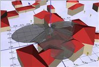
It is possible to perform a simulation of the electromagnetic field generated by the antennas by inserting a few parameters. The evolution of the main and secondary lobes of the electromagnetic field radiated by cellular and television systems is represented in 3D.
You will be able to compose the transmitting system as you wish according to the essential characteristics such as power, frequency, number of panels and the relative rotation-tilt angles, etc. to obtain results in real time that typically only experts know...